Broxtowe Borough Council refreshes its Blue and Green Infrastructure Strategy with LUC
Broxtowe Borough Council has launched a new Blue and Green Infrastructure (BGI) Strategy, prepared by LUC, to shape a more connected, climate-resilient and nature-rich borough.

A new strategy to link landscapes, water and people
The strategy brings together Broxtowe’s natural and built environments into a single, integrated network, recognising that parks, rivers, trees, canals and open spaces all play a vital role in creating places where communities and wildlife can thrive.
Replacing the Council’s 2015 Green Infrastructure evidence base, this refreshed strategy reflects the latest priorities for climate action, biodiversity recovery and community wellbeing. It also marks the first time that Broxtowe’s blue infrastructure, its rivers, canals and floodplains, have been fully mapped and planned alongside its green spaces.
A connected approach to people, place and nature
Blue and green infrastructure refers to the network of natural and semi-natural spaces that provide multiple benefits.
LUC’s strategy provides a strong framework to help guide planning, policy and investment across Broxtowe, ensuring that new development and regeneration projects contribute to this wider network.
Through a combination of spatial mapping and stakeholder engagement, the strategy highlights where action will deliver the greatest benefits, such as improving access to nature, restoring floodplains, and linking fragmented habitats.

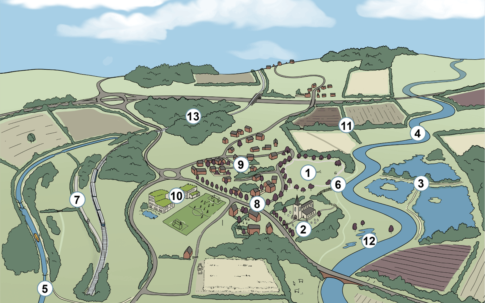
Six zones for action
To focus delivery, Broxtowe has been divided into six Blue and Green Infrastructure Zones that reflect the borough’s varied landscapes and communities:
- Erewash Valley – restoring wetlands, reconnecting the river with its floodplain and improving the popular Erewash Valley Trail.
- River Trent Corridor – expanding riparian habitats and using natural flood management to enhance resilience.
- Beeston and Stapleford Urban Fringe – creating pocket parks, improving active travel links and increasing tree canopy cover.
- A610 Urban Corridor – using urban greening to revitalise town centres and improve wellbeing.
- Babbington Rolling Farmlands – strengthening hedgerows and grasslands to support pollinators and landscape character.
- Eastern Farmed and Wooded Fringe – connecting ancient woodlands and restoring streams for biodiversity and water quality.
Each zone includes a five-year action plan, providing practical steps to guide future investment, partnerships and community projects.
Shaped by local insight
Public consultation helped shape the strategy’s priorities, with residents and community partners calling for more tree planting, better maintenance of existing green spaces, and inclusive access for people of all abilities. Many highlighted the borough’s blue corridors, such as the River Trent, Erewash and Nottingham Canal, as valuable but underused community assets.
Delivering long-term benefits for climate and community
By embedding blue and green infrastructure into the Council’s Local Plan and development guidance, Broxtowe is taking a major step towards a greener, healthier and more climate-resilient future.
The strategy aligns with the objectives of the Nottinghamshire Local Nature Recovery Strategy and will enable the Council’s Climate Change and Green Futures Strategy to be realised on the ground.
Through this work, LUC and Broxtowe Borough Council have created a clear, practical roadmap for connecting people and nature, ensuring that the Borough’s landscapes remain vibrant, accessible and sustainable for generations to come.
Recent news
 News, 10 December 2025
LUC sponsors national climate planning guide for local authorities
🌍 Thank you to everyone who joined our Mapathon. Whether you participated online or in the office, your efforts made a real impact. Together, over 40 attendees mapped 4,727 buildings in northern Côte d’Ivoire, where Médecins Sans Frontières is supporting refugees.
LinkedIn, 24 November 2025The most in-demand skills in planning consultancy 2025
Planning ResourcePress, 10 December 2025